On one side, Google Maps: The well known application offering satellite images (among other features) of the whole planet. This product has a nice interface very easy to use. Its only limitation, the areas in some countries (in this case, Spain) still not available as high resolution imagery.
On the other side, SIGPAC, the geographical information system from the Spanish Ministerio de Agricultura, Pesca y Alimentación. This application is publicly available, and it allows viewing ortophotos of the whole country in high detail level. The main drawbacks, are the images being a bit aged and a user interface suffering from some limitations.
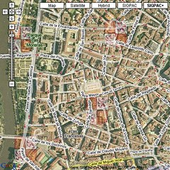
The solution: just to combine the best of the two systems. Let the Google Maps interface use the SIGPAC maps when viewing areas not available in high detail level, and to continue using the original Google Maps imagery when available in high detail.
Best of all, is that even using external maps (such as the SIGPAC ones), we can still combine the additional information coming from Google Maps. This way, we can see street and route maps properly placed all over the SIGPAC images.
Here, you can view the mix Google Maps + SIGPAC
Spanish version of this story here